Lineside vegetation, and its control, is always the subject of debate between those interested in the safe operation of the railway and those who value nature’s beauty and diversity.
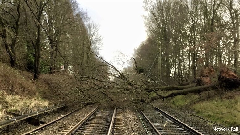
Trees growing close to the line shed their leaves on the track, causing low adhesion problems and delaying trains in the autumn. They also get blown over by storms, pulling down overhead cables, landing on the track and stopping train services, with the all-too-present risk of an accident as well.

Some argue that tree roots help stabilise embankments and cutting faces, so they do a good job. Others suggest that the trees suck all the moisture out of the ground, drying out the earthworks and actually destabilising them.
Then there is the general undergrowth which hampers access to the track, impedes visual inspection of earthworks and can even catch fire from sparks from heritage steam locomotives using the line, leading to them being banned from some sections of the national rail network.
In contrast, the Varley report of 2018 encouraged Network Rail to regard lineside vegetation as an asset rather than a liability, balancing the operation of a safe and reliable railway with positive environmental considerations and affording lineside vegetation the same importance as performance assets such as track and signalling.
Whatever the truth of it, the important thing is to actually know what vegetation is out there. Once the facts are known, then reasoned decisions can be made. One way to do this is to send teams of railway workers out to log trees and bushes, making reports on the state of every part of the railway. With 20,000 miles to cover, that would be a lot of people out on the railway, costing a fortune and potentially putting themselves at risk from passing trains.
Which is why geodata specialist Fugro has worked with Network Rail to develop intelligent remote solutions to monitor, measure and manage vegetation assets.
For some time, Fugro’s rail infrastructure alignment acquisition system (RILA) has been used to monitor both Network Rail’s track and its lineside assets. The equipment is mounted on a service train, either at the back of a passenger train or on a freight locomotive, and, using LiDAR and other methods, Fugro can produce a ‘map’ showing the railway as it actually is.

This approach has now been extended to vegetation management. Using data captured by Fugro’s FLI-MAP (helicopter) and RILA (train-mounted) lidar systems, it is possible to automatically classify the data and report areas where vegetation encroachment to the track or overhead line equipment (OLE) already exists or is imminently at risk of fouling the asset concerned. This enables targeted foliage clearance instead of the widespread felling of trees.
Similarly, both FLI-MAP and RILA are remotely operated systems that provide robust data that enables proactive intervention and year-on-year planning and a clearly defined health and safety benefit by negating the need for lineside patrols, monitoring and “boots on ballast”.
The combination of both tools can determine the position of individual trees, the aspect, slope and property that they are located on, and the likely direction and extent of any falling tree. This information enables engineers to assess the associated risk to track and OLE, contact system, and rolling stock. Using a simple traffic light approach denoting distance from track or OLE aligned to NR/L2/OTK/5201 Issue 4 standards, engineers can rapidly identify areas of encroachment.

Where both FLI-MAP and RILA data are available, the datasets can be merged to form a complete picture from top of canopy to ground level and tree bole position. The use of RILA, recorded near to track level, complements the aerial FLI-MAP lidar and reduces the dependency for leaf-off aerial survey to penetrate through the canopy to ground level. The tool is being further refined to identify primary species.

Utilising this information enables asset managers to enhance their ability to comply with the recent Module 3, Route Vegetation Management Plans, in the Lineside Vegetation Management Manual.
As individual species have variable but well understood growth rates, this enables predictive maintenance.
Additionally, species identification provides species-specific insights, for example ash trees, which may be prone to disease and present a particular danger of collapse or failure. With nearly 50 per cent of the network now recorded with RILA, the opportunity to capitalise on the existing data is significant.
In addition to the FLI-MAP and RILA lidar data that form the information source for the vegetation analysis, both systems collect simultaneous imagery and video that can be used in a desktop environment for further analysis, inspection and verification.
Fugro’s commitment is to continue to add remotely operated systems and technologies to assist Network Rail and other railway operators with their engineering, asset management and maintenance requirements.


Be the first to comment